
Former National Fireworks Site
 July 2017 | 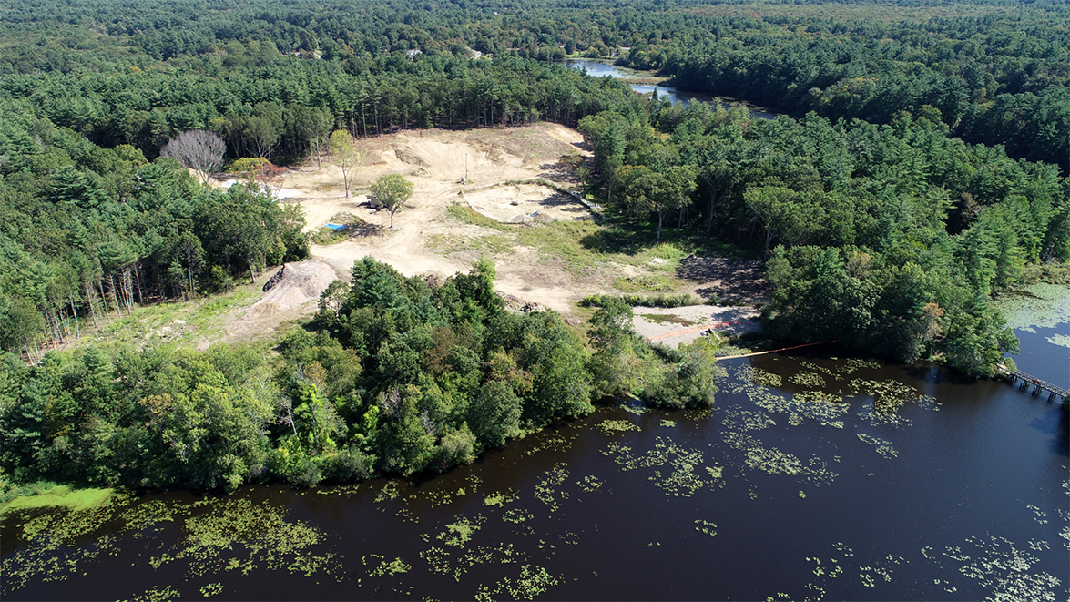 September 2019 |
CodeRed Notifications
Register online to receive our CodeRED automatic phone, text, and email service notifications and to learn more about the CodeRed system.
Meetings
Controlled Detonation Schedules
Detonation notices are posted to our Town News. Sign up to receive notices and other updates. You may also follow @HanoverMA on Twitter or Hanover, Massachusetts on Facebook for detonation updates.
| Dates | Time Frames | Notes |
|---|---|---|
| Friday, April 26, 2024 | 2:00 PM to 4:00 PM | |
| Thursday, April 18, 2024 | 2:00 PM to 4:00 PM | |
| Thursday, April 11, 2024 | 2:00 PM to 4:00 PM | |
| Thursday, March 28, 2024 | 2:00 PM to 4:00 PM | |
| Wednesday, November 15, 2023 | 3:00 PM to 4:00 PM | |
| Thursday, August 17, 2023 | 3:00 PM to 4:00 PM | |
| Thursday, June 8, 2023 | 3:00 PM to 4:00 PM | |
| Thursday, May 18, 2023 | 3:00 PM to 4:00 PM | |
| Thursday, April 27, 2023 | 2:00 PM to 4:00 PM | |
| Thursday, April 13, 2023 | 2:30 PM to 4:30 PM | |
| Friday, March 31, 2023 | 2:00 PM to 4:00 PM | |
| Friday, March 17, 2023 | 2:00 PM to 4:00 PM | |
| Friday, March 3, 2023 | 2:00 PM to 4:00 PM | |
| Friday, February 17, 2023 | 2:00 PM to 4:00 PM | |
| Friday, January 27, 2023 | 2:00 PM to 4:00 PM | |
| Friday, January 6, 2023 | 2:00 PM to 4:00 PM | |
| Friday, November 18, 2022 | 2:00 PM to 4:00 PM | |
| Friday, October 28, 2022 | 2:00 PM to 4:00 PM | |
| Thursday, September 29, 2022 | 2:00 PM to 4:00 PM | |
| Thursday. September 15, 2022 | 3:00 PM to 4:00 PM | |
| Friday, July 22, 2022 | 2:00 PM to 4:00 PM | |
| Friday, July 8, 2022 | 2:00 PM to 4:00 PM | |
| Friday, May 27, 2022 | 2:00 PM to 4:00 PM | |
| Friday, May 20, 2022 | 2:00 PM to 4:00 PM | |
| Friday, April 29, 2022 | 2:00 PM to 4:00 PM | |
| Friday, April 22, 2022 | 2:00 PM to 4:00 PM | |
| Friday, April 8, 2022 | 2:00 PM to 4:00 PM | |
| Friday, April 1, 2022 | 2:00 PM to 4:00 PM | |
| Friday, March 25, 2022 | 2:00 PM to 4:00 PM | |
| Friday, March 4, 2022 | 2:00 PM to 4:00 PM | |
| Friday, February 25, 2022 | 2:00 PM to 4:00 PM | Cancelled. |
| Friday, February 11, 2022 | 2:00 PM to 4:00 PM | |
| Friday, January 28, 2022 | 2:00 PM to 4:00 PM | |
| Thursday, December 16, 2021 | 2:00 PM to 4:00 PM | |
| Thursday, December 9, 2021 | 2:00 PM to 4:00 PM | |
| Friday, November 19, 2021 | 2:00 PM to 4:00 PM | |
| Friday, November 5, 2021 | 2:00 PM to 4:00 PM | |
| Friday, October 8, 2021 | 2:00 PM to 4:00 PM | |
| Friday, September 24, 2021 | 2:00 PM to 4:00 PM | Cancelled. |
| Friday, September 17, 2021 | 2:00 PM to 4:00 PM | |
| Friday, September 10, 2021 | 2:00 PM to 4:00 PM | |
| Friday, August 27, 2021 | 2:00 PM to 4:00 PM | |
| Friday, August 13, 2021 | 2:00 PM to 4:00 PM | |
| Friday, July 16, 2021 | 2:00 PM to 4:00 PM | |
| Friday, June 25, 2021 | 2:00 PM to 4:00 PM | |
| Friday, May 21, 2021 | 2:00 PM to 4:00 PM | |
| Friday, Apri 30, 2021 | 2:00 PM to 4:00 PM | |
| Friday, April 9, 2021 | 2:00 PM to 4:00 PM | |
| Friday, March 26, 2021 | 2:00 PM to 4:00 PM | |
| Friday, February 12, 2021 | 2:00 PM to 4:00 PM | |
| Wednesday, February 10, 2021 | 2:00 PM to 4:00 PM | |
| Friday, February 5, 2021 | 2:00 PM to 4:00 PM | |
| Friday, January 15, 2021 | 2:00 PM to 4:00 PM | Cancelled. |
| Friday, December 11, 2020 | 2:00 PM to 4:00 PM | |
| Friday, December 4, 2020 | 2:00 PM to 4:00 PM | |
| Friday, November 20, 2020 | 2:00 PM to 4:00 PM | |
| Friday, November 13, 2020 | 2:00 PM to 4:00 PM | |
| Thursday, October 29, 2020 | 3:15 PM to 4:00 PM | Scheduled siren test. No detonations. |
| Friday, October 23, 2020 | 2:00 PM to 4:00 PM | Scheduled siren test. |
| Friday, October 16, 2020 | 2:00 PM to 4:30 PM | |
| Friday, October 9, 2020 | 2:00 PM to 4:30 PM | |
| Friday, October 2, 2020 | 2:00 PM to 4:30 PM | |
| Friday, September 25, 2020 | 2:00 PM to 4:30 PM | |
| Friday, September 18, 2020 | 2:00 PM to 4:30 PM | |
| Friday, September 11, 2020 | 2:00 PM to 4:30 PM | |
| Friday, September 4, 2020 | 2:00 PM to 4:30 PM | |
| Friday, August 28, 2020 | 2:00 PM to 4:30 PM | |
| Friday, August 21, 2020 | 2:00 PM to 4:30 PM | |
| Friday, August 14, 2020 | 2:00 PM to 4:00 PM | |
| Friday, August 7, 2020 | 2:00 PM to 4:30 PM | |
| Friday, July 31, 2020 | 2:00 PM to 4:30 PM | |
| Friday, July 24, 2020 | 2:00 PM to 4:30 PM | |
| Friday, July 10, 2020 | 2:00 PM to 4:30 PM | |
| Friday, June 26, 2020 | 2:00 PM to 4:30 PM | |
| Friday, June 19, 2020 | 2:00 PM to 4:30 PM | |
| Friday, June 5, 2020 | 2:00 PM to 5:00 PM | |
| Friday, May 29, 2020 | 3:00 PM to 4:00 PM | |
| Friday, May 15, 2020 | 2:00 PM to 5:00 PM | |
| Friday, May 8, 2020 | 2:00 PM to 5:00 PM | |
| Friday, May 1, 2020 | 2:00 PM to 5:00 PM | |
| Friday, April 24, 2020 | 2:00 PM to 5:00 PM | |
| Friday, April 10, 2020 | 2:00 PM to 5:00 PM | |
| Friday, March 27, 2020 | 2:00 PM to 5:00 PM | |
| Friday, March 20, 2020 | 2:00 PM to 5:00 PM | |
| Friday, March 13, 2020 | 2:00 PM to 5:00 PM | |
| Friday, March 6, 2020 | 2:00 PM to 4:30 PM | |
| Thursday, March 5, 2020 | 2:00 PM to 5:00 PM | |
| Wednesday, March 4, 2020 | 2:00 PM to 5:00 PM | |
| Friday, February 28, 2020 | 2:00 PM to 5:00 PM | |
| Friday, February 27, 2020 | 2:00 PM to 5:00 PM | |
| Friday, February 21, 2020 | 2:00 PM to 5:00 PM | |
| Friday, February 14, 2020 | 2:00 PM to 5:00 PM | |
| Friday, February 7, 2020 | 2:00 PM to 5:00 PM | |
| Wednesday, February 5, 2020 | 2:00 PM to 5:00 PM | |
| Friday, January 31, 2020 | 2:00 PM to 4:00 PM | There may be up to eight detonations. |
| Wednesday, January 29, 2020 | 2:00 PM to 4:00 PM | |
| Friday, January 24, 2020 | 2:00 PM to 4:00 PM | |
| Friday, January 17, 2020 | 2:00 PM to 4:00 PM | |
| Friday, January 10, 2020 | 2:00 PM to 4:00 PM | |
| Friday, January 3, 2020 | 2:00 PM to 4:00 PM | |
| Friday, December 13, 2019 | 2:00 PM to 4:00 PM | |
| Friday, December 6, 2019 | 2:00 PM to 4:00 PM | |
| Friday, November 15, 2019 | 2:30 PM to 4:30 PM | |
| Thursday, November 7, 2019 | 2:30 PM to 4:30 PM |