
Damaging Winds, Heavy Rain, and Thunderstorms through Tonight 4/13/20
 A strong storm system lasting through tonight has the potential to bring damaging winds, heavy rain, and thunderstorms to the New England region. The greatest time of concern is late this morning into early evening.
The strong, damaging winds associated with this storm are currently impacting the region resulting in electric customer outages. Based upon the most recent National Weather Service (NWS) forecast, the area for highest wind gusts, while still uncertain, is expected to be interior southeast MA including the city of Boston. The peak period of wind and rain is forecast until 8:00 pm this evening.
If power is lost, please plan to shelter in place for 24-48 hours. As we practice social distancing, this is the safest approach for residential safety. If you have an emergency, call 911.
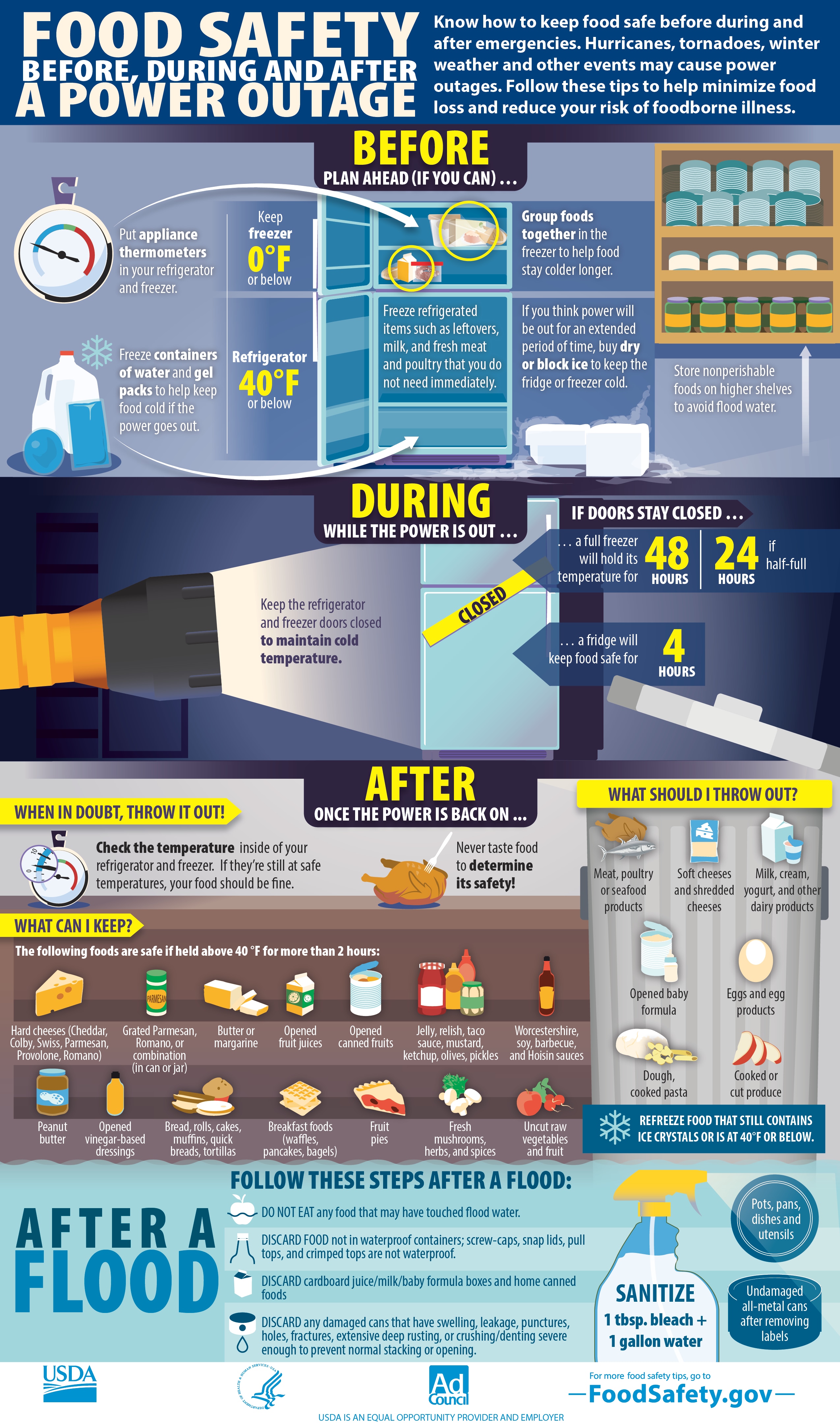
Food Safety Before, During, and After A Power Outage
- Food Safety for Power Outages
- Find out how to keep food safe before, during, and after emergencies, such as floods, fires, natural disasters, or the loss of power
Preparing for an Emergency or Power Outage
- Hanover EMA - Emergency Preparedness
- Mass.gov - Safety Tips for Specific Threats & Hazards
- National Grid Live Updates
Current Weather in Hanover, MA
- Realtime Weather Information at Hanover Fire Headquarters
- AccuWeather.com, Hanover, MA
- Weather.com, Hanover, MA
Advisory - April 13, 2020
High Winds
Southerly wind gusts of 55 to 70 mph are possible late this morning through this evening, with sustained winds of 20-40 mph. The highest winds are expected across southeast Massachusetts including the Cape and Islands, but damaging wind gusts are possible across all of southern New England.
Heavy Rain/Thunderstorms
There is a low risk of an isolated thunderstorm this afternoon and early tonight. Some of these storms could become severe bringing damaging winds. Widespread rainfall amounts of 1 to 2 inches are possible through early tonight. Isolated amounts up to 3 inches are possible, especially where any thunderstorms move through.
Impacts
- Scattered to widespread power outages are possible due to downed trees, tree limbs and power lines.
- High winds will result in hazardous travel conditions for high profile vehicles.
- Heavy rain may cause brief localized urban and poor drainage flooding. Some small streams may approach Action stage.